FACULTY
教員紹介
FACULTY

Professor
NISHINA Daisaku
西名 大作 教授
建築環境学研究室
Architectural Environment Laboratory
専門
環境心理学
Environmental Psychology
研究の概要説明
都市環境・都市空間は建築物のみならず,道路や鉄道,港湾などの土木構造物,河川や森林,海浜などの自然環境など,様々な要素によって構成されている。それらの集合体としての都市環境・都市空間で,日常生活を営んでいる私たちは,それらから様々な情報を獲得し,心理的な影響を受けている。その一方で,それらに対して様々な反応や行動をとり,さらには改変してきている。人間とそれを取り巻く環境との相互作用に着目し,その一端を明らかにしていくことで,人間にとって真に快適な環境の創造を目指す。
Urban environments and urban spaces are composed of various elements, including not only buildings but also civil engineering structures such as roads, railways and ports, and natural environments such as rivers, forests and beaches. We spend our daily lives in the urban environment and urban space as an aggregate of these elements. We acquire various information from them and receive psychological influences. On the other hand, we react and behave in various ways to them, and have even modified them. By focusing on the interaction between humans and their surrounding environment and clarifying some aspects of this interaction, we aim to create a truly comfortable environment for humans.
現在の研究テーマ
・地方中小商店街における街路景観の心理的評価
・VR空間による観光体験の行動特性
・観光景観に対する心理的評価の国際比較
・水辺のオープンカフェにおける人々の利用行動特性
・都市空間指標による河川景観の心理的評価予測モデル
・The psychological evaluation of streetscapes in small and medium-sized local shopping streets
・Behavioural characteristics of tourism experiences in VR spaces
・International comparison of psychological evaluation of tourism landscape
・Behavioural characteristics of people’s use of riverside open cafés
・Prediction model for psychological evaluation of river landscape by urban spatial indices.
研究室サイト
広大研究者総覧
研究・プロジェクト内容
ドローン技術に基づく詳細な緑情報を活用した CG 画像の河川景観評価における適用可能性
現在,GISを用いた都市景観予測技術が発展しているが,緑に関する情報が不足しているため,実際に近い景観シミュレーションは困難である。本研究は,河川景観を対象に,河岸沿いにドローンを飛行させることで取得した画像情報に基づいて,緑の平面形状,高度情報を整備し,より精緻に構築された緑を含むCG画像を作成する。
Applicability of CG images utilized detailed greenery information based on drone technology for river landscape evaluation
Currently, GIS-based urban landscape forecasting techniques are being developed, but due to a lack of information on greenery, it is difficult to simulate landscapes that are close to reality. This study aims to develop information on the planform and altitude of greenery based on image information obtained by flying a drone along a river bank, and to create CG images including more precisely constructed greenery for river landscapes.
-300x200.png)
外国人観光客の誘致を意図した地域の観光資源に対する心理的評価の国際比較
日本への外国人観光客は増加の一途をたどっているが,多くは東京や大阪などの大都市圏に集中しており,地域の活性化を図る上でインバウンド需要は十分に役立っていない。日本人にはあまり評価されないが,外国人には高く評価される地域の観光資源を発見することを意図して,広島県内の複数の観光資源を対象に,日本人と中国人を被験者として画像評価実験,実空間評価実験を行い,結果の比較を進めている。
International comparison of psychological evaluation of local tourism resources intended to attract foreign tourists
Although the number of foreign tourists to Japan continues to increase, most are concentrated in metropolitan areas such as Tokyo and Osaka, and inbound demand has not been sufficient to help revitalize of local areas. With the intention of discovering local tourism resources that are not highly valued by the Japanese, but are highly valued by foreigners, image evaluation experiments and real-space evaluation experiments are being conducted on several tourism resources in Hiroshima Prefecture with Japanese and Chinese subjects, and the results are being compared.


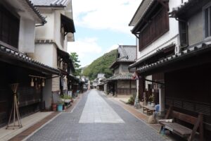
同種の街並みの相互比較による地域活性化を致した視覚的固有性の導出
伝統的建造物群保存地区の指定による整備・改修は,それぞれの地域が有する独自性を喪失させる可能性がある。また,地方中小都市の商店街は,それぞれ独自な雰囲気を有するものの,相互の差異が認識されておらず,来街者の増加に結び付いていない。これらの状況をふまえ,同種の街並みを地域間で比較する実験の遂行により,それぞれの地域の特徴を「視覚的固有性」として抽出,地域活性化に活かす試みを進めている。
Derivation of visual identities with the intention of regional revitalization through the comparison between streetscapes in similar types of regions
The maintenance and renovation of designated traditional building preservation areas may result in the loss of the uniqueness of each area. In addition, although the shopping streets of small and medium-sized local cities have their own unique atmosphere, the differences between them are not recognized, and this has not led to an increase in the number of visitors to the streets. From the viewpoint of these circumstances, we attempt to extract the characteristics of each region as ‘visual identities’ and utilize them for regional revitalization by carrying out an experiment to compare similar streetscapes between regions.